Coastal Watches/Warnings and 5-Day Track Forecast Cone
Hurricane SANDY Advisory #019 11:00 PM EDT Fri October 26, 2012
from: National Hurricane Center (check link for updates!)
 |
| Paul Beckwith, B.Eng, M.Sc. (Physics), Ph.D. student (Climatology) and Part-time Professor, University of Ottawa |
All storms veer to the right in the northern hemisphere due to the spinning of the earth (1 revolution per day). Except when there is a tilted high pressure region northward and it has to go left and there is a massive low pressure region left that sucks it there as well.
Why the high pressure ridge and massive low pressure? Because the jet stream is wavier and slower, a situation that is happening more and more often, because of massive sea ice decline this summer. Which is due to Arctic amplification feedbacks. Which in turn is due to rising greenhouse gases. Which is due to humans.
The situation is further illustrated by the image below, from ClimateCentral.
 |
| An atmospheric "blocking pattern" will push Sandy north, then northwestward, into the Mid-Atlantic or Northeast. Click to enlarge the image. Credit: Remik Ziemlinski, Climate Central. |
We dodged a bullet, at least this year. This luck will surely run out. What can we do about this? How about getting our politicians to listen to climatologists, for starters.
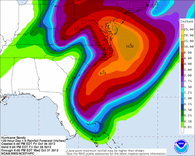
Below, rainfall forecast from the Hydrometereological Prediction Center of the National Weather Service - check the link for updates!
Related
- Vanishing Arctic sea ice is rapidly changing global climatearctic-news.blogspot.com/2012/09/vanishing-arctic-sea-ice-is-rapidly-changing-global-climate.html
- Storm enters Arctic region
arctic-news.blogspot.com/2012/09/storm-enters-arctic-region.html
- Diagram of Doom
arctic-news.blogspot.com/2012/08/diagram-of-doom.html
- Diagram of Doom
arctic-news.blogspot.com/2012/08/diagram-of-doom.html
arctic-news.blogspot.com/2012/08/huge-cyclone-batters-arctic-sea-ice.html


Tidak ada komentar:
Posting Komentar