Tampilkan postingan dengan label extreme. Tampilkan semua postingan

Sabtu, 22 November 2014

How melting Arctic ice is driving harsh winters

by Nick Breeze

The very least 'global warming' could do for us is to give us warmer winters, right? Wrong, writes Nick Breeze, who met climate scientist and meteorologist Jennifer Francis in his attempt to understand the complex interactions of jet stream, polar vortex, the melting Arctic, and the extreme snowfall that's hitting the northeast US right now.

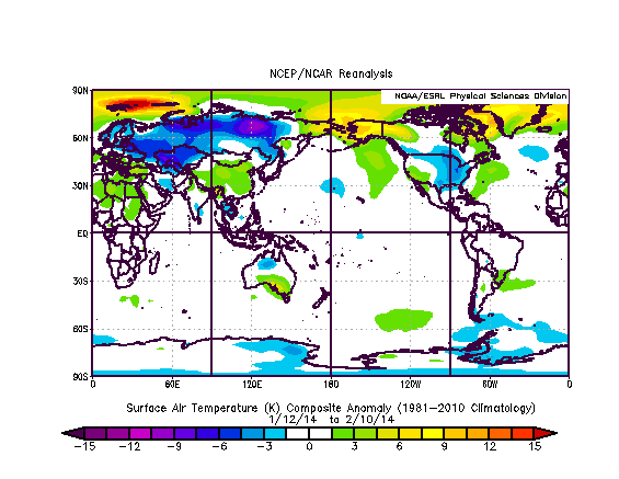
"Historic" snowfalls have the US northeast this week, with Buffalo, New York under an astonishing 2.4m (8ft) of snow - enough to cause some roofs to cave in under the pressure.

It's just the latest chapter in 2014 unprecedented range of weather extremes - from persistent storms that battered, and flooded much of the UK at the beginning of the year, before going on to record the hottest October since records began.

And in the US, extremes have ranged from California's record drought, to the early snows now under way in the northeast - and let's not forget the 'polar vortex' that hit much of the US in January, bringing Arctic conditions as far south as Texas and Florida, causing flights to be cancelled in Chicago as aviation fuel froze in the -38.3C (-37F) temperatures.


Scientists now have evidence that these persistent extreme weather patterns are increasing in their frequency, due to the rapid heating up of the Arctic that is changing the behaviour of the jet stream, and in turn, the polar vortex.

And Jennifer Francis of Rutgers University, one of the leading US scientists studying the relationship between Arctic warming and changes in the jet stream, believes that it's thanks to 'global warming' that northern hemisphere weather is becoming more extreme - and it's not about to get any better.

Screenshot from Youtube video further below

The 'vast river of wind' that makes our weather

"The Arctic is generally very cold", she told me, "and the areas farther south are warm, and that difference in temperature between those two areas is really what fuels that vast river of wind moving high over our head that we call the jet stream."

"The jet stream in turn creates most of the weather that we feel all around the northern hemisphere and the middle latitudes, so anything that affects this jet stream is going to affect weather patterns. So as the Arctic warms up much faster than the areas farther south, we're seeing this temperature difference between these two regions get smaller."

The result of that, she explains, is that the atmospheric forces driving the jet stream's circular motion are getting smaller - and that means the winds themselves in the jet stream are getting weaker, and moving more slowly.

"When that happens, the jet stream tends to take a wavier path as it travels around the northern hemisphere and those waves are actually what create the stormy patterns and the nice weather patterns. As those waves get larger because of this weakening of those winds of the jet stream, they tend to move more slowly from west to east."

"That means it feels like the weather patterns are sticking around longer, because those patterns are moving much more slowly and this then makes it more likely to have the kind of extreme events that are related to persistent weather patterns."


Are critical findings influencing policy?

These changes in climate have huge implications. As Dr Francis points out, there are "people who worry about whether there is enough fresh water to supply cities, whether there is enough snowpack on mountains to supply reservoirs, and for agriculture ..."

"Drought and agriculture is a big problem. Storminess in certain areas is another big problem. Yes, it has a huge impact for a whole range of issues that affect the way we live."

It's no wonder then that Dr Francis and her colleagues have attracted the attention of President Obama's chief science advisor, Dr John Holdren.

Dr Holdren has been reporting directly to the President on the real time effects of climate change and is keen to understand what this new research tells us about the future impact of changes to the jet stream.

Asked about this sudden interest in her work from the US Presidency, Francis muses thoughtfully. "Yes, we've had a lot of interest from policy makers", she acknowledges.

"I think we're starting to make a lot of progress now in getting policymakers to understand that this is a big problem they have to face ... I think decision makers and the policymakers at the local level get it much better because they're already seeing effects on their local areas.

"Sea level rise is an obvious one. They're already seeing changes in drought and agricultural problems and dealing with fresh water issues. It is really at the local level that we're having more success."

New research supports the case that Arctic sea ice loss is driving climate changes

So to understand the changes in the jet stream it's important to research how the vast atmospheric river of weather above our heads is connected to other climate mechanisms.

"It appears that over the north Atlantic, and towards Asia, there's a mechanism that appears to be quite robust, and several groups have found this mechanism using completely different analysis techniques", says Francis referring to new research by colleagues at the University of Alaska that has emerged in the last couple of months.

"So what we're finding is that there's an area, north of Scandinavia in the Arctic, where the ice has been disappearing particularly rapidly. When that ice disappears ... there is unfrozen ocean underneath, and that ocean absorbs a lot more energy from the sun through the summertime. So it becomes very warm there."

"Then as the fall comes around, all that heat that's been absorbed all summer long, where the ice has retreated, is put back in the atmosphere and that creates a big bubble of hot air ... over that region where the ice was lost."

And in turn, that goes on to disrupt the circumpolar winds whose behaviour determines much the weather across the northern hemisphere.

The gigantic bubble of warm air "tends to create a northward bulge in the jet stream", and in turn, "that creates a surface high pressure area that circulates in the clockwise direction. That sucks cold air down from the Arctic over northern Eurasia, and that creates a southward dip in the jet stream."


The bulging jet stream disrupts the polar vortex

"So what we're getting is this big northward bulge up over Scandinavia and a southward dip over Asia ... creating, first the tendency for a larger wave in the jet stream, which tends to move more slowly, but also we're seeing this mechanism that creates these colder winters that have been observed over Central Asia."

"Once the jet stream gets into this wavier pattern, it sends wave energy up into the highest levels of the atmosphere, which is called the stratosphere, where we have the polar vortex, which is kind of similar to the jet stream but it's much higher up in the atmosphere and it travels much faster."

"So as that wave energy gets sent up from this larger wave below, up into the stratosphere, it breaks down that polar vortex so that it becomes wavier as well. That wavier polar vortex sends energy back down to the lower atmosphere and it creates an even wavier jet stream in February."

"So we're seeing this connection of mechanisms that starts with Arctic sea ice loss and it makes a wavier jet stream for different reasons all the way through winter."

Will the jet stream continue to cause changes in climate?

By identifying these mechanisms and linking them back directly to loss of the Arctic sea ice, Dr Francis and her colleagues are demonstrating how man-made global warming is creating feedbacks that are changing the climate conditions in the northern hemisphere - and not for the better.

It may be counterintuitive, and it when it first happened it took scientists by surprise - but now it looks like this is one of the most important ways in which 'global warming' is hitting North America. Melting ice in the Arctic Ocean is indirectly pushing frigid Arctic air south across the continent, creating the perfect conditions for massive snowfall.

Which is all very well ... but what's coming next? "We are using these climate models, or computer simulations ... to try and project what we're expecting to see happen in the future, as greenhouse gases continue to increase.

"The early indications are that these large wavy patterns in the jet stream are going to become more frequent in the future, as far as we can tell. It is preliminary research that I haven't published yet but it does look as if they are going to increase."


Nick Breeze is a film maker and writer on climate change and other environmental topics. He has been interviewing a range of experts relating to the field of climate change and science for over four years. These include interviews with Dr James Hansen, Professor Martin Rees, Professor James Lovelock, Dr Rowan Williams, Dr Natalia Shakhova, Dr Michael Mann, Dr Hugh Hunt, among others.

Additional articles can also be read on his blog Envisionation.

Jennifer Francis is a research professor at the Institute of Marine and Coastal Sciences at Rutgers University, where she studies Arctic climate change and the link between Arctic and global climates. She has authored more than 40 peer-reviewed publications on these topics. She was also the co-founder of the Rutgers Climate and Environmental Change Initiative.

Article earlier posted at TheEcologist.org


Related


Jumat, 16 Mei 2014

More extreme weather can be expected


The heaviest rains and floods in 120 years have hit Serbia and Bosnia this week, Reuters and Deutsche Welle report.

The animation below shows the Jet Stream's impact on the weather. Cold temperatures have descended from the Arctic to Serbia and Bosnia in Europe and all the way down to the Gulf of Mexico in North America, while Alaska, California, and America's East Coast are hit by warm temperatures. In California, 'unprecedented' wildfires and fierce winds lead to 'firenadoes', reports CNN.


The image below shows that on May 15, 2014, the wind approaching Serbia and Bosnia at 700 hPa reached speeds of up to 120 km per hour (75 mph), as indicated by the green circle on the main image and inset.


The image below, from skeptical science, shows the cyclonic spin that can be expected in a through such as the one that hit Serbia and Bosnia recently.


As the Jet Stream changes, more extreme weather events can be expected. What makes the Jet Stream change? As the Arctic is warming up faster than the rest of the world, the temperature difference between the Arctic and the equator decreases, in turn decreasing the speed at which the Jet Stream circumnavigates the globe. This can cause 'blocking patterns', with extreme weather events hitting an area longer than before.

As the jet stream becomes wavier, cold air can more easily descend from the Arctic down to lower latitudes in a downward through of the Jet Stream, while warm air can more easily reach higher latitudes in an upward ridge of the Jet Stream.

This spells bad news for many areas across the world that can be expected to be hit by more extreme weather events such as heatwaves, wildfires fuelled by stronger winds and more intense drought, storms and floods.

Heatwaves are a huge threat in the Arctic, especially when followed by storms that can cause warm surface water to mix down to the bottom of the sea and warm up sediments under the seafloor that can contain huge amounts of methane in the form of hydrates and free gas. The situation is dire and calls for comprehensive and effective action, as discussed at the Climate Plan blog.


Related

- Extreme weather strikes around the globe - update
http://arctic-news.blogspot.com/2014/02/extreme-weather-strikes-around-the-globe-update.html

- Escalating extreme weather events to hammer humanity (by Paul Beckwith)
http://arctic-news.blogspot.com/2014/04/escalating-extreme-weather-events-to-hammer-humanity.html

- Our New Climate and Weather (by Paul Beckwith)
http://arctic-news.blogspot.com/2014/01/our-new-climate-and-weather.html

- Our New Climate and Weather - part 2 (by Paul Beckwith)
http://arctic-news.blogspot.com/2014/01/our-new-climate-and-weather-part-2.html

- Changes to Polar Vortex affect mile-deep ocean circulation patterns
http://arctic-news.blogspot.com/2012/09/changes-to-polar-vortex-affect-mile-deep-ocean-circulation-patterns.html

- Polar jet stream appears hugely deformed
http://arctic-news.blogspot.com/2012/12/polar-jet-stream-appears-hugely-deformed.html


Sabtu, 15 Februari 2014

Extreme weather strikes around the globe - update

As the weather gets more extreme, disaster strikes around the globe. The Guardian reports three people killed as storms continue to batter southern UK. The Vancouver Sun reports that a U.S. Northeast snowstorm kills 25. And the Sacramento Bee reports Six dead and 1,000 injured in fresh Japan snow storm.

What is the story behind these extreme weather events? The image below tells the story. The Arctic has been much warmer than it used to be, due to numerous feedbacks that accelerate warming in the Arctic. This reduces the temperature differential between the Arctic and lower latitudes, which changes the Jet Stream and Polar Vortex, in turn making the weather at many places ever more extreme.

 earlier forecasts by cci-reanalyzer.org
Above image illustrates the situation, showing an Arctic Ocean that is warmer than the higher latitudes of the Asian and North American continents.

Arctic sea ice has meanwhile reached record lows, as illustrated by the image below.


The situation can be expected to get even worse. The image below shows sea ice extent, as measured by the NSIDC, which is one day ahead compared to above image.


Below, two regular contributors to the Arctic-news blog comment on the situation.


    Paul Beckwith:

Paul Beckwith with sign (arrows highlighted by Sam Carana, from earlier post)
In the video below, Paul Beckwith discusses the above sign and the situation in general.


Dr. Malcolm Light, Earth Scientist, comments:


The volume of water transported by Gulf Stream off the east coast of the United States has increased by three times since the 1940s due to a massive increase in wind drag. This increase in the south westerly wind drag is a result of the continuously increasing pressure difference set up between the continental air mass over North America, heated by fossil - fuel generated carbon dioxide, and the marine air of the Atlantic.

The increased energy entering the Gulf Stream as heat and its associated winds and storm systems are what are now pummeling Great Britain and Europe. This heat is also transported further north by branches of the Gulf Stream into the Arctic Ocean, where it is destabilizing the subsea methane hydrates, releasing increasing volumes of methane into the Arctic atmosphere and causing temperature anomalies this last winter of more than 20 degrees Celsius.

As a consequence of the extremely high Arctic temperatures and pressures, the normal freezing Arctic air has been displaced into Canada and the United States, causing catastrophic blizzards that have never been seen before. When the floating Arctic ice cap melts towards the end of next year, the Arctic Ocean will then become more aggressively heated by the sun and the northern offshoots of the Gulf Stream.

Under these circumstances, the cold Arctic air will be confined over the Greenland ice cap and the Arctic atmosphere will rotate anticlockwise around Greenland, transferring the fast-increasing amounts of its atmospheric methane to Canada and the United States and causing a further increase in the energy of the Gulf Stream.

Therefore the United Kingdom and Europe must brace themselves for even more catastrophic weather systems, widespread flooding and massive wind damage from the start of the last quarter of next year.


Below is a comparison of methane readings for the week from February 9 to 16, 2014, compared to the same period in 2013.


The comparison shows that there is a lot of methane over the Arctic Ocean that wasn't there last year. Furthermore, high methane readings show up where currents move the sea ice out of the Arctic Ocean, in areas such as Baffin Bay. This indicates that methane that is released from the seafloor of the Arctic Ocean appears to be moving underneath the ice and entering the atmopshere where the sea ice is fractured or thin enough to allow the methane to pass through.

Also note that more orange areas show up on the southern hemisphere in 2014, indicating that more methane from the northern hemisphere is now spreading south beyond the equator. This in addition to indications that more methane is rising and building up at higher altitudes, as discussed in an earlier post.

As said before, the situation calls for comprehensive and effective action, as discussed at the Climate Plan blog.


Senin, 10 Februari 2014

Extreme weather strikes around the globe

  Editorial note: this post has meanwhile been updated as
Extreme weather strikes around the globe update.


As the weather gets more extreme, disaster strikes around the globe.

Here's a snapsnot from today's news. In London, the BBC reports, flooded homes along the River Thames are being evacuated and thousands more are at risk. In Japan, reports Reuters, eleven people died, more than a thousand were injured and tens of thousands lost power when the worst snowstorm in decades hit Tokyo and areas around the Japanese capital before heading north to blanket the tsunami-hit Pacific coast. Many countries in the Middle East were hit by snow. The BBC reports that heavy snow in northern Iran has left around 480,000 homes without power and some towns and villages cut off.

What is causing these extreme weather events? The image below tells the story. While at times it has been cold at many places around the world, when averaged over the past 30 days, temperatures around the globe have actually been several degrees higher than they used to be. The Arctic has been hit hardest, with anomalies as high as 21°C over this 30 day period. This affects the Jet Stream and Polar Vortex, which in turn is making the weather ever more extreme.


The situation is further illustrated by the cci-reanalyzer.org forecasts below.


And while the sea ice didn't look too bad at the start of the year, growth has meanwhile stopped, as illustrated by the image below.


Added below are two videos by Paul Beckwith, further discussing the situation.


Editor's note: Reanalysis of temperature anomaly Jan 12 - Feb 10, 2014.
Meanwhile, I've added another image (above), created with NOAA's reanalysis, which compares temperatures to a larger dataset, and the colors look a lot different, so NOAA may indeed have mixed the colors up somewhat in the initial image, as Albert suggested at the Facebook discussion (click on image below).

Anyway, the point made in the post remains, i.e. that as global warming continues, warming in the Arctic accelerates more rapidly than at lower latitudes, which weakens the polar vortex and jet stream in a self-reinforcing feedback that causes the Arctic to warm up even further compared with lower latitudes.

As said, the situation calls for comprehensive and effective action, as discussed at the Climate Plan blog.


Kamis, 20 Juni 2013

Extreme weather becomes the norm - what can you do?

. . a sky that has turned red due to greenhouse gases, while the land is flooded. The handful of
people who survived are standing by helplessly on higher grounds, in despair and without hope,
while one figure turns to me in panic and pain, uttering nothing but a silent scream . . .
(comment by Sam Carana, March 8, 2012, on auction of the Scream, by Edvard Munch)

Symptoms

Torrential rains in some regions are causing massive floods while in other locales record droughts are occurring with higher frequency and severity and areal extent around the globe. Global food production is being hit hard, leading to large price increases and political instability. Areas under drought are experiencing numerous massive forest fires of incredible ferocity.

Causes

The statistics of extreme weather events have changed for the worst due to changes in the location, speed, and waviness of the jet streams which guide weather patterns and separate cold and dry northern air from warm and moist southern air. The jet streams have changed since the equator to north-pole temperature difference has decreased due to the huge temperature rise in the Arctic.

The huge temperature rise in the Arctic is due to a collapse in the area of highly reflective snow and ice, which is caused by melting. The melting is from warming from the increase of greenhouse gases from fossil fuel burning. The Arctic sea ice and spring snow cover will vanish within a few years and the weather extremes will increase at least 10x.

What can you do?

Go talk to you politicians and friends about climate change and the need to slash fossil fuel emissions. Immediately. Cut and paste my comments above and post them on facebook, send them to newspapers, and educate yourself on the science behind all the above linkages. Leave my name on or take it off and plagiarize all you want, just get this knowledge out there...

From an unmuzzled climate scientist...
Paul Beckwith, B.Eng, M.Sc. (Physics),
Ph.D. student (Climatology) and Part-time Professor,
University of Ottawa

originally posted as a comment under the CBCnews post:
Calgary braces for flooding, orders communities evacuated 

Related

- The Tornado Connection to Climate Change
- President Obama, here's a climate plan!
- Diagram of Doom
- Polar jet stream appears hugely deformed
Ten Dangers of Global Warming (originally posted March 8, 2007)

Jumat, 21 Desember 2012

Methane contributes to accelerated warming in the Arctic


Above combination image featured earlier in the post Striking increase of methane in the Arctic. The images were produced by Dr. Leonid Yurganov, Senior Research Scientist, JCET, UMBC, who presented his findings at the AGU Fall Meeting 2012. The image below gives an update for 2012, showing an image with methane levels at 600 hPa.


Temperature anomalies on the inset on above image are averages for the full month November, whereas the methane levels displayed on the left are for the first ten days of November only. Using temperature maps for the same periods in such comparisons may result in even more striking simularities between methane levels and temperatures. For a more complete picture, further comparisons between November 2008 and November 2012 are added, for days 11-20 (below),


and for days 21-30 (below).


The images show that the highest methane levels show up above the water, as opposed to above land, indicating that methane is being released from the seabed across the Arctic.

Temperatures have meanwhile changed. In November 2012, there were high temperature anomalies in east Siberia. There now are very low temperatures throughout Siberia, as illustrated by the Wunderground map below, which shows high temperatures. Temperatures as low as -60.5°F (-51.4°C) were recorded in Susuman, east Siberia, both on December 13th and 17th, 2012.


The now hugely deformed polar jet stream and high levels of methane in the Arctic are only two out of numerous feedbacks that contribute to accelerate warming in the Arctic. Without rapid action, we can expect such wild swings in temperature to get even worse, making more extreme weather the new norm.

Kamis, 08 November 2012

Iklan Iklan Paling Mengerikan

Iklan tidak hanya sebuah gambar semata dari sang empunya namun  merupakan "senjata" yang bisa menghipnotis dan mengedukasi kepada calon konsumen tentang apa maksud dan tujuan pesan dari iklan tersebut. Di jaman sekarang sebuah iklan haruslah sangat kreatif! seperti contoh iklan susu muler dari jerman. Selain kreatif, iklan yang kontroversial juga mampu menyita perhatian publik, contoh foto para pemimpin dunia yang berciuman bibir.


Ariel Plus: Ketchup

Karabine
Caribu Bitter: Canari

Alka-Seltzer: New Year

Concordia Children’s Services: Piglets

Procter & Gamble / Febreze: Fly

Colombian Association of Arterial Hypertension: Home

Nycomed: Agony

One Life Shower

Pedestrian Council of Australia: Family

10 Serangga Dengan Nama Menyeramkan

 
Assassin Bug berbaring menunggu mangsanya, lalu menyergap seperti James Bond melakukan aksi pada misi rahasia. Assassin Bug memiliki tombak pembunuh, korban yang malang ditusuk dengan paruh melengkung dan menyuntikkan enzim mematikan. Beberapa jenis Assassin Bug adalah pembunuh haematophagous, yang berarti pengisap darah.


2. Robber Fly

Serangga bermata besar ini ditakdirkan untuk membunuh. Lalat perampok Robber Fly "mempersiapkan" mangsa mereka dengan menusuk dengan paruh mereka, kemudian menyuntikkan combo ampuh enzim yang melumpuhkan korban dari dalam. Serangga ini memiliki 5 buah mata dan memiliki kemampuan yang sangat baik dalam mengamati mangsa favoritnya yaitu lalat lain, ngengat, capung dan bahkan laba-laba.

3. Wolf Spider

Dengan taring berbisa besar dan delapan mata dari berbagai ukuran, laba-laba serigala melakukan patroli mencari mangsanya.

4.Ant Lion


Semut Singa telah berevolusi dengan sangat kompleks dan memiliki metode unik untuk membunuh mangsanya. Mereka membangun sebuah lubang kerucut di pasir ldan bersembunyi tepat di bawah lubang tersebut. Apa pun yang tergelincir ke dalam perangkap semut singa akan kesusahan meloloskan diri.

5.Death’s-Head Hawkmoth

Hawkmoths tidak langka, ulat besar mereka sering ditemukan pada tanaman tomat. Hawkmoths ngengat yang unik di antara ngengat lainnya karena kemampuan mereka membuat nada tinggi menggerenyet ketika mereka jengkel. Death's-head hawkmoths memiliki tampilan menakutkan, pola seperti tengkorak di punggung mereka dan membuat mangsanya dan kita gelisah.

6.Killer Bees

Lebah Pembunuh adalah lebah pemarah, bersayap, dilengkapi alat penyengat dan cocok untuk pepatah "jangan main-main dengan alam!" Keturunan mereka dapat menahan kerasnya iklim tropis.

7. Tiger Mosquito


Sebelumnya keberadaannya terbatas pada wilayah hutan dan lahan basah di Asia Tenggara, namun seiring perjalanan manusia nyamuk ini telah menyebar dengan habitat baru di seluruh dunia.

8. Hickory Horned Devil


Hickory Horned Devils adalah ulat dari Regal, atau Royal Walnut ngengat. Ulat ini mirip dengan hawkmoths tetapi dalam spesies ini "tanduk"-nya lebih panjang, berwarna hitam & merah. Dikombinasikan dengan tubuh pirus cerah, tanduk benar-benar menonjol sehingga membuat pemangsa berpikir dua kali untuk memangsa mereka.


9. Vampire Moth

Ngengat Vampir ditakdirkan untuk mengisap darah dari mangsa di habitat asli mereka ,kerbau dan juga manusia jika diberi kesempatan.

10. Bee Wolf
Beewolves, juga dikenal sebagai Tawon Penggali. 


Rabu, 07 November 2012

10 Perjalanan Terekstrim di Dunia

10 Perjalanan Terekstrim di Dunia

Perjalanan panjang dan jauh mungkin akan cukup melelahkan bagi kita namun tidak dengan 10 orang ini mereka melakukan perjalanan panjang demi memenuhi hasrat kepuasan dalam perjalanan merka namun perjalan 10 orang berikut ini bukan perjalanan biasa ke extremeanya dalam melakukan perjalanan lah yang membuat mereka luar biasa. Mau tahu perjlanan seperti apa aja itu simak 10 Perjalanan Manusia Paling Extreme berikut ini.

1. Pendeta Baptis Merangkak 1.600 Mil ke Gedung Putih.
 Pada tahun 1978, Hans Mullikin seorang pendeta yang berusia 39 tahun tiba di Gedung Putih setelah merangkak 1.600 Mil dari Marshall, Texas. Kakinya terbungkus bulu dan berselubung dalam baja galvanis tipis, salah pada lengan kursi rodanya lebih kecil dari yang lain untuk mengimbangi dalam berjalan. Pada November 1978 ia mengakhiri dua setengah tahun merangkaknya hanya untuk mendengar dari seorang pembantu bahwa Presiden Carter terlalu sibuk untuk melihatnya. “Aku hanya ingin menunjukkan kepada Amerika bahwa kita perlu berlutut dan berdoa” kata Mullikin kepada wartawan. “Ini adalah sesuatu yang saya miliki dalam hati saya dan ingin saya lakukan untuk negara saya”.


2. Orang Australia Yang Mengelilingi Dunia Dengan Kendaraan Amphibi.
Ben Carlin, seorang warga Australia, mengambil tantangan untuk mengelilingi dunia dalam sebuah mobil jip amphibi yang dimodifikasi. Dia berangkat dengan Elinore istrinya pada tahun 1950. Instrinya akhirnya sadar dan keluar ekspedisi di suatu tempat di india pada sekitar ¾ perjalanan. Tapi Ben meneruskan perjalanan dengan teman-teman lainnya yang akhirnya menyelesaikan perjalanan pada tahun 1958. Perjalanan dimulai dan berakhir di Montreal, Kanada. Butuh waktu 8 tahun, mencakup 62.000 Km di darat dan 17.000 Km di laut.

3. Orang Yang Menyelesaikan 4.115 km Mendorong Gerobak Untuk Mengumpulkan Uang Untuk Penelitian Kanker

David Baird menyelesaikan perjalanan Herculesnya selama 112 hari mendorong gerobak sorong di seluruh Australia (yang menempuh jarak 4.115 km atau 2.557 mil dengan berjalan kaki). Dia melakukan ini untuk mengumpulkan uang guna penelitian kanker payudara dan prostat. Pria berusia 65 tahun ini mengatakan dia merasa “luar biasa baik”, mengingatkan bahwa ia telah menempuh 4.115 km dengan berjalan kaki.

 Dia berlari setara dengan seratus lari marathon penuh hanya dalam 112 hari. Melewati sekitar 70 kota di sepanjang jalan, Baird mengatakan bahwa ia mendorong gerobak antara 10 sampai 12 jam sehari. Ia tidak pernah ragu bahwa ia tak akan menyelesaikan perjalanannya, ia mengaku setiap hari adalah “keras”. Upaya amal ini berjalan dengan baik dan simpatisan melemparkan lebih dari $20.000 ke dalam gerobak itu.


4. Orang Yang Benar-Benar Berlari Mengitari Seluruh Dunia.

Pelari inggris Robert Garside, yang juga dikenal sebagai “Runningman”, dinobatkan oleh Guinness World Record sebagai orang pertama yang berlari mengelilingi dunia. Garside mulainya rekor berjalan setelah beberapa percobaan yang dibatalkan untuk meninggalkan Cape Town, Afrika Selatan, dan London, Inggris. Akhirnya Garside berangkat dari New Delhi, India pada tanggal 20 Oktober 1997, dan menyelesaikan larinya pada titik yang sama pada tanggal 13 Juni 2003. 


Upaya Garside ini telah dipertanyakan oleh para pelari lainnya dan juga pers. Karena kesulitan yang melekat sertifikasi rekening tersebut, Guinness World Record menghabiskan beberapa tahun mengevaluasi bukti sebelum menyatakan otentik.


5. Siswa Yang Berjalan 3.000 Kilometer Dari Beijing Ke Jerman Dan Membuat Film Pendek.

Hadiah ulang tahun Christoph Rehage untuk dirinya sendiri pada bulan November 2007 adalah pergi berjalan jauh. Rencananya adalah berjalan dari Beijing, Cina (dimana dia adalah mahasiswa disana) ke rumahnya di Bad Nenndorf, Jerman. Sebuah proposisi yang luar biasa, jika anda mempertimbangkan luasnya Cina.


Sepanjang jalan ia memotret dirinya sendiri dan membuat video. Kita melihat seorang muda, laki-laki yang telah bercukur bersih diubah oleh perualangannya. Ada penderitaan fisik yang jelas terlihat yaitu: salju dan pasir menyala dari gurun Gobi yang panjang, jalan raya kosong, dan rasa sakit yang lamban tak terbatas. Rambut dan jenggotnya tumbuh liar. Rehage menemukan cinta, dan mungkin juga patah hati.
Setelah satu tahun, rehage memutuskan untuk berhenti berjalan dan kembali ke sekolah.


6. Gadis 16 Tahun Yang Mencoba Menyelesaikan Perjalanan Keliling Dunia Sendirian
 Seorang gadis berusia 16 tahun, Jessica Watson semakin dekat ke akhir mengelilingi dunianya, sebuah perjalanan yang akan membuat dia menjadi yang termuda dalam mengelilingi dunia seorang diri. Lahir dan dibesarkan di Queensland Sunshine Coast, jessica dijadwalkan tiba di Sydney sekitar 9 Mei untuk menjadi seorang pahlawan yang disambut untuk certitanya untuk dipatenkan. 

“The Rupert Murdoch Empire” telah memberikan hak paten atas dirinya dan keluarganya. Jessica, yang masih berumur 12 tahun ketika dia mengatakan kepada orang tuanya bahwa ia ingin berlayar mengelilingi dunia seorang diri, meninggalkan Sydney pada tangal 18 Oktober 2009 yang meskipun tidak dapat menyelesaikan perjalanannya dan harus kembali ke Sydney karena kerusakan mesin setelah menempuh lebih dari 200 hari perjalanan


7. Orang Yang Berjalan 13.000 km Mundur Dari California, Amerika Serikat Ke Turki
Plennie L. Wingo (24 Januari 1895 – 2 Oktober 1993) berjalan mundur dari Santa Monica, California, ke Istambul, Turki (sekitar 13.000 km atau 8.000 mil) sejak tanggal 15 April 1931 sampai 24 Oktober 1932 pada usia 36 tahun. Dia mendokumentaikan perjalanannya dalam buku “Around The World Backwards”.
Untuk melakukannya dia menggunakan kacamata periscopic, yang diikat diatas telinganya seperti kacamata biasa, yang memungkinkan dia untuk melihat dimana ia berjalan. Dia berjalan rata-rata sekitar 20 mil perhari.


8. Orang Yang Berjalan 1.830 mil Diatas Egrang
Pada tahun 1891 Sylvain Dornon, dari Landes, berjalan diatas egrang dari Paris ke Moskow melalui Vilno (1.830 mil) dalam 50 tahap (36,6 mil sehari). Ia memulai perjalanannya pada 12 Maret 1891. Meskipun perjalanan panjang diatas egrang ini merupakan sebuah rasa ingin tahu yang asli, hal ini sebenarnya tidak hanya ada di Rusia, tetapi juga banyak orang Perancis yang melakukannya sebelum tahun 1870-an di bagian tertentu dari Perancis.


9. Orang Yang Bepergian Selama 12 Tahun Dari Afrika Ke Greenland Untuk Menemukan Tempat Bebas Ular

Tete-Michel Kpomassie lahir pada tahun 1941, di Togo. Ketika ia masih muda, ia berada di hutan ketika ia terkejut dengan Phyton, dan jatuh ke tanah. Ayahnya percaya bahwa penyakitnya yang dihasilkan hanya dapat disembuhkan dengan konsultasi kepada pendeta sekte Python, jauh didalam hutan, sehingga ia dibawa kesana pada satu malam yang panjang, ke jantung sekte penuh ular. Obat itu bekerja, tapi pendeta tersebut meminta pembayaran. Kpomassie harus diinisiasi ke dalam kultus ular dan hidup di hutan untuk tujuh tahun, diantara ular.


Pada saat ini, ia telah sembuh dari penyakitnya dan menemukan sebuah buku anak-anak tentang Greenland. Negara ini tidak hanya aneh karena tidak ada ular disana, tetapi juga tidak ada pohon-pohon dimana ular bisa bersembunyi. Dia langsung jatuh cinta dengan negara ini dan kabur dari rumah, dengan ide tunggal entah bagaimana menuju Greenland, dan akhirnya pada pertengahan 1960-an menemukan perahu ke Greenland. Kisah petualangannya di Greenland dapat ditemukan dalam bukunya, yang diterbitkan di Perancis pada tahun 1977, “An African In Greenland”.


10. Orang Yang Pergi Berjalan Lintas Negara Amerika Serikat Untuk Menurunkan Berat Badan.
Steve Vaught melakukan sebuah tantangan yang luar biasa mulai tahun 2005 untuk berjalan di Amerika Serikat. Dia memulai perjalanan 3.000 milnya dari Oceanside, California untuk pulang ke Manhattan pada tanggal 10 April 2005, ketika pada saat itu ia ditimbang seberat 410 pound dan menderita depresi berat setelah tidak sengaja menewaskan dua pejalan kaki saat mengemudi 15 tahun yang lalu. Ia berhasil menghilangkan lebih dari 100 pound berat badannya dalam proses ini.
 Tetapi perjalanan Vaught itu bukan tanpa kontroversi. Pertanyaan dilontarkan oleh media dan penggemar, apakah Vought rides benar-benar berjalan setiap milnya. Vaught juga masih belum sehat dari obesitas setelah menyelesaikan perjalanannya. Dalam pembelaannya ia berkata “Anda tidak bisa curang, tidak ada cara yang mungkin untuk menipu.. ini adalah perjalananku.. aku tidak peduli tentang dimana aku berada kemana aku akan pergi, aku tidak peduli apakah itu adalah 2.800 atau 1.500 mil.. ini tentang dimana kepala anda”. 

sumber

Jumat, 02 November 2012

10 Cuaca Teraneh di Dunia

10 Cuaca Teraneh di Dunia

10 Cuaca Paling Aneh / Teraneh Di dunia - terdapat cuaca aneh yang sangat tak wajar. Seperti langhit berdarah, hujan ikan, bom es hingga bulan biru. Fenomena alam yang menarik. Seperti apa?

Hujan Ikan dan Katak

Dari California , Inggris hingga India , secara periodik terjadi presipitasi (hujan) aneh. Hewan kecil seperti ikan, katak dan ular jatuh dari langit beberapa kilometer dari air. Puting beliung yang berputar di danau atau samudra dapat menghisap air dan apapun yang ada di dalamnya ke awan di atasnya.

Bola Api Besar

Selama berabad-abad, orang melaporkan keanehan listrik di rumah mereka, terutama selama badai petir. Bola cahaya seukuran bola golf hingga bola sepakbola terkadang melayang di udara selama badai dan memancarkan panas serta suara.

Bola ini biasanya akan hilang ketika mengenai benda berlistrik seperti TV namun terkadang bisa meledak dengan ganas dan menyebabkan kebakaran. Bola cahaya ini tak hanya mistis juga membuat ilmuwan bingung.

Langit Berdarah

Hujan darah terdengar seperti film horor Hollywood . Namun, pada zaman Romawi kuno, hujan ini dikabarkan pernah terjadi. Meski menakutkan, hujan ini sebenarnya bukanlah darah.

Warna merah disebabkan debu atau pasir yang tertiup ke atmosfer dan dibawa angin kuat dan akhirnya bercampur dengan awan hujan dan mewarnai hujan. Di Eropa, hujan merah ini diwarnai debu yang ada di benua itu dari badai pasir Sahara .

Tiga Matahari

Di hari yang cerah, langit juga bisa memberi kejutan, setidaknya untuk mata. Jika matahari dekat dengan horizon dan awan cirrus berada di atasnya, ‘hantu’ tiga matahari akan bersinar di langit.

Matahari hantu ini sebenarnya cahaya terang yang tercipta ketika cahaya matahari dicerminkan oleh kristal kecil yang ada di awan. Meski hal ini merupakan fenomena optik umum, fenomena ini tak selalu muncul.

Bulan Biru

‘Bulan biru’ terjadi tiap dua setengah tahun ketika bulan purnama terjadi dua kali dalam satu bulan kalender. Terdapat peristiwa langka ketika bulan tampak biru. Kebakaran hutan dan gunung api dapat menembakkan abu ke atmosfer dan tercampur tetesan air.

Tetesan air ini dapat bergerak ribuan kilometer mengelilingi Bumi dan cukup untuk membuyarkan cahaya matahari dan membuat bulan berwarna biru.

Monster Laut

Monster Loch Ness mungkin hanya ungkapan berlebihan dari kolom putaran air. Angin puyuh kecil yang terkadang disebut ‘iblis air’ ini dapat mengubah air hangat menjadi corong.

Iblis air ini dapat berputar dan mengeluarkan suara desis. Suara ini dipadukan dengan tampilan seperti berleher panjang dan membuatnya terkesan seperti monster laut menakutkan yang akan melompat menyerang Anda.

Angin Puyuh Berapi

Meski tak ganas, iblis debu ini bisa sangat mengerikan. Angin puyuh ini merupakan versi kecil tornado yang terbentuk ketika panas bertemua tanah menyebabkan udara dan angin di atasnya berputar.

Angin puyuh ini tercampur debu dari tanah. Angin puyuh ini memiliki saudara yang lebih menakutkan, yakni iblis api. Iblis api terbentuk ketika panas intens hutan kebakaran menciptakan tali api yang berputar dengan ganas di atas kebakaran itu.

Sprite, Jet dan Elf

Selama bertahun-tahun, pilot melaporkan kilatan berwarna aneh yang keluar dari ujung badai awan dan membuat banyak orang tak percaya. Namun kini, ilmuwan menemukan bukti jenis petir aneh ini memang ada. Sprite merah merupakan ledakan cahaya merah yang berada 80,5 km di atas Bumi dan biasanya muncul dalam lebih dari dua kluster.

Saudaranya, Jet biru, merupakan kerucut cahaya biru yang terjadi di bagian atmosfer yang lebih rendah dari Sprite merah. Jet biru yang terjadi bersamaan dengan Sprite merah disebut Elf. Cahaya merah berbentuk panekuk yang tercipta dari petir di bawahnya. Kilatan ini hanya terjadi seperseribu detik dan ilmuwan terus menyelidi apa pemicunya.

Api Santo Elmo

Selama badai petir, banyak orang melaporkan bola ‘api’ berdansa di atas kapal. Bola api kecil bernama api Santo Elmo ini merupakan listrik statis yang timbul selama badai petir. Meski tak berbahaya, bola api kecil ini bisa terjadi sebelum ada sambaran petir. Bola api ini bisa menjadi pengingat agar Anda menjauh.

Bom Es

Kebanyakan orang yang pernah mengalami badai petir pernah mengalami hujan es sebesar bola kasti. Namun, pada beberapa hujan es, bisa jauh lebih besar (tercatat 40 kilogram) jatuh dari langit.

Lebih misteriusnya, bongkahan es ini terkadang jatuh ke Bumi tanpa adanya awan di langit. Sementara beberapa hujan es terbukti terjadi karena ada es yang jatuh dari sayap pesawat, beberapa hujan es masih tak bisa dijelaskan apa penyebabnya
 
Sumber:http://forum.vivanews.com/showthread.php?t=91825

Rabu, 24 Oktober 2012

7 alat penyiksaan paling sadis dan menyeramkan

7 alat penyiksaan paling sadis dan menyeramkan

Alat penyiksaan paling sadis dan menyeramkan - Pada zaman pertengahan, penyiksaan terhadap tubuh orang yang menjalani hukuman akibat tindakan kriminal adalah sebuah hal yang dianggap biasa. Penyiksaan ini tentu saja bertujuan agar yang menjalani penyiksaan merasakan penderitaan yang setimpal dengan perbuatan mereka.

Dari sekian banyak alat penyiksaan yang digunakan, ada beberapa alat yang dianggap paling sadis dan menyeramkan. Beberapa dibawah ini adalah diantaranya :

1. The Peer


Alat berbentuk mirip buah pir yang diujungnya ada duri yang bisa dipanjangkan dengan cara memutar bagian belakang dari alat ini. Alat ini dibuat untuk menghukum mereka yang bertindak asusila seperti sodomi, pemerkosaan, dll. Alat ini dipaksakan untuk masuk ke mulut, atau vagina, atau lubang anus, setelah alat dimasukkan duri yang ada diujungnya dipanjangkan sehingga langsung menusuk bagian dalam organ mereka.

2. Tongue Tearer


Alat ini bertujuan untuk mencabut lidah korban dengan paksa dan digunakan untuk mengintimidasi atau mengancam korban untuk mendapatkan informasi

3. Thumb Crusher


Alat ini dapat menghancurkan jari-jari dan digunakan sebagai hukuman untuk orang yang suka mencuri

4. Breast Ripper


Alat ini berfungsi untuk mencabut payudara dengan paksa dan digunakan sebagai hukuman bagi wanita yang suka bertindak asusila dan pelacur.

5. The Saw


Alat yang digunakan adalah gergaji, korban diletakan secara terbalik kemudian digergaji perlahan-lahan dimulai dari pantat sampe orang tersebut tewas.

6. Spiked Chair


Alat ini berupa kursi yang terdapat duri-duri dari besi yang sangat tajam, korban dipaksa duduk sehingga darah akan mengalir dengan deras sampai korban tersebut tewas.

7. Rack


Alat ini berupa rak kayu tempat meletakan korban, orang yang dihukum diikat di sebuah rak kayu. Rak kayu tersebut memiliki roler yang ada di ujung-ujung rak kayu yang bisa diputar menyebabkan ikatan tali semakin kuat. Semakin diputer, tubuh orang yang diikat semakin tertarik sehingga menyebabkan sendi-sendi tulangnya hampir putus dan bisa sampai putus.