Tampilkan postingan dengan label melt. Tampilkan semua postingan

Jumat, 15 Agustus 2014

Heatwave to hit Greenland

A heatwave with temperature anomalies exceeding 36°F (20°C) is expected to hit Greenland between August 16 and 22, 2014, as illustrated by the image on the left and the animation on the right. 

Such heatwaves can be expected to hit the Arctic more frequently and with greater intensity, as temperatures in the Arctic are rising faster than elsewhere on Earth.

Such heatwaves can result in massive melting on Greenland, as persistent heat changes the texture of the snow and ice cover, in turn reducing its reflectivity. This makes that less sunlight is reflected back into space and is instead absorbed. 

The image below illustrates what a difference the presence of sea ice can make.
from: Arctic Warming due to Snow and Ice Demise
As the NSIDC/NOAA graphs below shows, melting on Greenland has been relatively modest this year when compared to the situation in 2012. By July 12, 2012, 97% of the ice sheet surface had thawed, according to this NASA analysis and this NOAA Arctic Report Card.


Melting on Greenland directly affects sea level rise, and melting on Greenland is accelerating due to a number of factors.

Projections of melting on Greenland have long been based on a warming atmosphere only, ignoring the warmer waters that lubricate glaciers and that warm Greenland's bedrock canyons that sit well below sea level.

Furthermore, there are growing quantities of black carbon deposits as a result of burning of fossil fuel and biomass. High temperatures have recently caused ferocious wildfires in Canada that have in turn caused a lot of black carbon to go up high into the atmosphere.

And of course, the atmosphere over the Arctic is warming up much faster than most models had projected. This in turn causes triggers further feebacks, including more extreme weather events such as heatwaves and rain storms that can be expected to hit Greenland with ever more frequency and ferocity. Further feedbacks include methane eruptions from the heights of Greenland, as discussed at the Arctic Feedbacks Page.

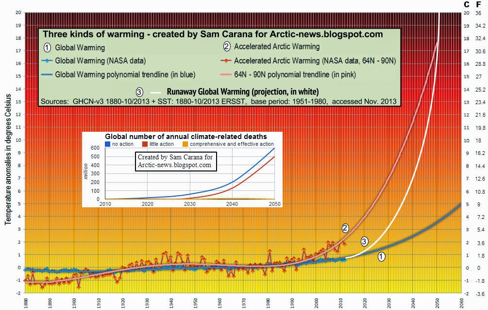
When also taking into account the accelerating impact of such factors on melting in Greenland, sea levels could rise much faster than anticipated, as illustrated by the image below.

from: more than 2.5m sea level rise by 2040? 

Note that sea level rise is only one of the many dangers of global warming, as discussed in the 2007 post Ten Dangers of Global Warming.

The image on the right shows a temperature forecast for August 16, 2014, with parts of Greenland changing in color from blue into green, i.e. above the melting point for snow and ice.

Such high temperatures are now hitting locations close to the North Pole ever more frequently, due to the many feedbacks that are accelerating warming in the Arctic, as discussed at this Feedbacks page.

One of the most dangerous feedbacks is a sudden eruption of huge quantities of methane from the seafloor of the Arctic Ocean, as discussed in a recent post.

The impact of such feedbacks can be accumulative and interactive, resulting in self-reinforcing feedbacks loops that can escalate into runaway warming.

Below is another forecast by ClimateReanalyzer for August 16, 2014, showing the remarkable ‘greening’ of Greenland, as well as the very high temperatures reaching the higher latitudes of North America.


Also see the very high sea surface temperatures around Greenland on the image below, created with ClimateReanalyzer.

Sea surface temperature anomalies on August 15, 2014. 
In conclusion, the situation is dire and calls for comprehensive and effective action, as discussed at the Climate Plan blog


Selasa, 29 Juli 2014

More than 2.5m Sea Level Rise by 2040?

A warming period more than 400,000 years ago pushed the Greenland ice sheet past its stability threshold (which may have been no more than several degrees above pre-industrial temperatures). This resulted in a nearly complete deglaciation of southern Greenland, raising global sea levels some 4.5-6 meters, found a recent study by Reyes et al. Due to melting elsewhere, global mean sea level then was 6 to 13 metres above the present level. Indeed, melting of the entire West Antarctic Ice Sheet can add a further 6-meter rise in sea levels. If the East Antarctic Ice Sheet (EAIS) were to melt as well, sea levels would rise by around 70 metres.

Sea level is now rising by 3.1mm (0.122 inch) per year. Much of this rise is due to rising temperatures, but there are also other factors. One quarter of the rise results from groundwater depletion, while run off from melting ice and glaciers adds another quarter and the remainder is attributed to thermal expansion of sea water. Furthermore, as temperatures rise, feedbacks start to kick in, e.g. the kinetic energy from stronger waves and more intense storms can speed things up.

Clearly, a rapid multi-meter rise would be devastating as it would flood many coastal cities, as well as much of the land now used to grow food. By how much have sea levels been rising recently and how fast can they be expected to rise in the near future?
NASA image, data by the JPL PODAAC, in support of the NASA's MEaSUREs program.
Sea levels have risen by some 60 mm over the past 20 years, as above NASA image shows, which has a linear trendline added. The question is whether a linear trendline is the most appropriate trendline, given that it suggests that a similar rise could be expected over the next 20 years. A polynomial trendline appears to fit the data better, as the animation below shows.


Such a polynomial trendline, however, points at a similar rise (of some 50 mm) in just four years time, with an even more steeper rise to follow, as illustrated by the image below.


And indeed, such a rise doesn't slow down there. A polynomial trendline applied to the data points at a sea level rise of more than 2.5 m (8.2 ft) by the year 2040.


The image below gives an idea of what a sea level rise of six feet (1.829 m) would do to the City of New York. Of course, this is only the sea level rise. Storm surge would come on top of this, as discussed at Ten Dangers of Global Warming.


So, what would be more appropriate, to expect sea levels to continue to rise in a linear way, or to take into account feedbacks that could speed things up? Where such feedbacks could lead to is illustrated by the image below.
[ from: How many deaths could result from failure to act on climate change? click on image to enlarge ]
This calls for comprehensive and effective action, as discussed at the Climate Plan blog.


References

- South Greenland ice-sheet collapse during Marine Isotope Stage 11, Reyes et al. (2014)
http://www.nature.com/nature/journal/v510/n7506/full/nature13456.html

- Nonsustainable groundwater sustaining irrigation: A global assessment, Yoshihide Wada et al. (2012)
http://onlinelibrary.wiley.com/doi/10.1029/2011WR010562/abstract

- Groundwater Depletion Linked to Rising Sea Levels
http://www.waterworld.com/articles/2010/11/groundwater-depletion-linked-to-rising.html

- Assessment of the Jason-2 Extension to the TOPEX/Poseidon, Jason-1 Sea-Surface Height Time Series for Global Mean Sea Level Monitoring, Beckley et al. (2010)
http://www.tandfonline.com/doi/abs/10.1080/01490419.2010.491029

- Feedbacks in the Arctic
http://climateplan.blogspot.com/p/feedbacks.html

- How many deaths could result from failure to act on climate change? (2014)
http://arctic-news.blogspot.com/2014/05/how-many-deaths-could-result-from-failure-to-act-on-climate-change.html


Sabtu, 05 April 2014

River ice reveals new twist on Arctic melt

A new study led by Lance Lesack, a Simon Fraser University geographer and Faculty of Environment professor, has discovered unexpected climate-driven changes in the mighty Mackenzie River’s ice breakup. This discovery may help resolve the complex puzzle underlying why Arctic ice is disappearing more rapidly than expected.

Lance Lesack,
photo by Simon Fraser University
Lesack is the lead author on Local spring warming drives earlier river-ice breakup in a large Arctic delta. Published recently in Geophysical Research Letters, the study has co-authors at Wilfrid Laurier University, the University of Alberta and Memorial University.

Its goal was to understand how warming global temperatures and the intensifying Arctic hydrological cycle associated with them may be driving increasing water discharges and more rapid ice breakup in the Arctic’s great rivers.

But the researchers stumbled upon an unexpected phenomenon while trying to figure out why the Mackenzie River’s annual ice breakup has been shortening even though its water discharge isn’t increasing, as in Russian rivers.

Just slightly warmer springs with unexpected snowfall declines — rather than warmer winters or increasing river discharge, as previously suspected — can drive earlier-than-expected ice breakup in great Arctic rivers.

The Mackenzie exemplifies this unexpected phenomenon. The researchers discovered this by accessing records dating back to 1958 of the river’s water levels, snow depths, air temperatures and times of ice breakup.

This finding is significant, as Arctic snow and ice systems are important climate-system components that affect the Earth’s ability to reflect solar radiation.

Mackenzie delta river, before (top) and after
(bottom, one day later) onset of dynamic ice
breakup in the central Mackenzie's delta middle
channel. Photos by Simon Fraser University.
“Our surprising finding was that spring temperatures, the period when river-ice melt occurs, had warmed by only 3.2 degrees Celsius. Yet this small change was responsible for more than 80 per cent of the variation in the earlier ice breakups, whereas winter temperatures had warmed by 5.3 degrees but explained little of this variation,” says Lesack.

“This is a strong response in ice breakup for a relatively modest degree of warming, but further investigation showed that by winter’s end snow depths had also declined by one third over this period. The lesser snow depths mean less solar energy is needed to drive ice breakup.”

Lesack says this is the first field-based study to uncover an important effect of reduced winter snowfall and warmer springs in the Arctic — earlier-than-expected, climate-change-related ice breakup.

“The polar regions have a disproportionate effect on planetary reflectivity because so much of these regions consist of ice and snow,” says Lesack. “Most of the planetary sea ice is in the Arctic and the Arctic landmass is also seasonally covered by extensive snow. If such ice and snow change significantly, this will affect the global climate system and would be something to worry about.”

Lesack hopes this study’s findings motivate Canadian government agencies to reconsider their moves towards reducing or eliminating ground-based monitoring programs that measure important environmental variables.

There are few long-term, ground-based snow depth records from the Arctic. This study’s findings were based on such records at Inuvik dating back to 1958. They significantly pre-dated remote sensing records that extend back only to 1980. Without this longer view into the past, this study’s co-authors would still be in the dark about the more rapid than expected Arctic melt and planetary heat-up happening.


Backgrounder:

Quotes by Lance Lesack
  • “Our work suggests that the effects of reduced winter snowfall should be further investigated in other aspects of the changing Arctic, such as the surprisingly rapid reduction in sea-ice cover and the unexpected collapses of several Canadian ice shelves.” 
  • “Our findings should also be of interest to people and industries that exist in the Arctic, where changes in the growth and decay of rivers, lakes or sea-ice may affect their daily lives. Ice roads and shipping over them depend on knowing when the ice roads can be travelled upon or when ferry crossings can be operated during open water.”
Facts:
  • Canada’s Mackenzie and several Russian rivers are among the Arctic’s gigantic waterways. The hydrological cycle is the cycling of water from the oceans to the atmosphere and back down to the continents, which the rivers then drain back to the ocean. Planetary warming hastens this cycle, which should lead to higher river discharge, more rapid river ice breakup, and ultimately more extreme weather patterns. 
  • About a third of the size of Switzerland and reaching 200 kilometres inland, the Mackenzie River delta sits at the end of Canada’s longest river and sustains 45,000 lakes. 
  • The Mackenzie River delta and other Arctic deltas are considered biological hotspots because their sites have much higher biological productivity and biodiversity than their surrounding Arctic environment. Their peak river levels enhance marine ecosystems by flushing nutrients and organic matter from vast deltas that sit at freshwater-ocean water interfaces into the ocean. 
  • In 2007 SFU geographer Lance Lesack co-authored a study that found rising water levels in the Mackenzie River delta, induced by climate-related sea-level rise, were three times higher than predicted. The authors worried that the faster-than-expected changes could have important impacts on the region’s human and animal life, and industry.
    Press release by Simon Fraser University
    http://www.sfu.ca/pamr/media-releases/2014/river-ice-reveals-new-twist-on-arctic-melt.html

    Local spring warming drives earlier river-ice breakup in a large Arctic delta
    Lance F. W. Lesack, Philip Marsh, Faye E. Hicks and Donald L. Forbes


    Selasa, 13 Agustus 2013

    Arctic Death Spiral - Evolution to July 2013

    Image by Andy Lee Robinson, from http://haveland.com/share/arctic-death-spiral.png
    The video below is a visualization of the Arctic Death Spiral showing the evolution of the volume of sea-ice over time from 1979 to July 2013.

    The rate of ice loss in the Arctic is staggering. Since 1979, the volume of Summer Arctic sea ice has declined by more than 80% and is accelerating faster than scientists believed it would, or even could melt.


    Pitch of the notes are proportional to the average sea-ice volume for each month. Spectral filters are derived from the average sea-ice volume for each year. Produced using Perl and PovRay, Midi perl and Reason and Virtualdub on a cluster of Linux servers.


    Above image is another way to visualize the data. It is a screenshot from the video below, by Andy Lee Robinson, illustrating the dramatic decline since 1979 until July 2013.

    Andy Lee Robinson
    The soundtrack "Arctic Requiem" also by Andy Lee Robinson, is available for free download: http://haveland.com/share/Arctic-Requiem.mp3

    Sea Ice Volume is calculated using the Pan-Arctic Ice Ocean Modeling and Assimilation System (PIOMAS, Zhang and Rothrock, 2003) developed at APL/PSC.

    Source data is available from:
    http://psc.apl.washington.edu/wordpress/research/projects/arctic-sea-ice-volume-anomaly/


    Kamis, 07 Februari 2013

    Arctic Sea ice Volume and Greenland Melt Update

    Arctic Sea Ice Volume

    The image below, from the ArctischePinguin site, shows the current volume of Arctic sea ice, updated with PIOMAS data from the Polar Science Center of the University of Washington.
    As the above image shows, a minimum volume of 3000 cubic km is expected to be reached in September 2013 (red dotted line), with a margin of error that allows for the sea ice to disappear altogether in a few months time.

    The image below updates the exponential trends for each month.

    Greenland Melt

    Meanwhile, the National Snow and Ice and Data Center (NSIDC) has started a page with daily updates of the extent of the Greenland melt. The image below pictures the Greenland melt in 2012 on the left, and the situation up to February 6, 2013 on the right.


    Jumat, 28 Desember 2012

    Albedo changes in the Arctic

    How global warming and feedbacks are causing huge albedo changes in the Arctic.

    Snow cover decline

    Decline of the snow cover on land in the northern hemisphere is accelerating, as illustrated by the image below and the image underneath on the right. (1)


    Image credit: Rutgers University
    Fresh snow can have an albedo as high as 0.85, meaning that up to 85% of the sunlight falling on snow can get reflected back into space. As the snow melts, its structure changes making it less reflective, i.e. its albedo will go down, to as low as 40%. (2)

    As a result, more sunlight gets absorbed, accelerating the melting process. Eventually, where snow melts away, spots of bare soil become exposed, and dark wet soil has a very low albedo, reflecting only between 5% and 15% of the sunlight. Thus, even more sunlight gets absorbed and the soil's temperature increases, causing more of the remaining snow to melt. (2)

    Changes in vegetation can further accelerate this process. Russia's boreal forest - the largest continuous expanse of forest in the world - has seen a transformation in recent years from larch to conifer trees. Larch trees drop their needles in the fall, allowing the vast, snow-covered ground in winter to reflect sunlight and heat back into space and helping to keep temperatures in the region very cold. But conifers such as spruce and fir retain their needles, which absorb sunlight and increase the forest's ground-level heat retention. (3)

    Albedo, from Wikipedia
    A conversion from larch to evergreen stands in low-diversity regions of southern Siberia would generate a local positive radiative forcing of 5.1±2.6 W m−2. This radiative heating would reinforce the warming projected to occur in the area under climate change. (4)

    Tundra in the Arctic used to be covered by a white blanket of snow most of the year. However, as the landscape is warming up, more trees and shrubs appear. Scientists who studied part of the Eurasian Arctic, found that willow and alder shrubs, once stunted by harsh weather, have been growing upward to the height of trees in recent decades. They now rise above the snowfall, presenting a dark, light-absorbing surface. This increased absorption of the Sun's radiation, combined with microclimates created by forested areas, adds to global warming, making an already-warming climate warm even more rapidly. (5 & 6)

    Furthermore, encroachment of trees onto Arctic tundra caused by the warming may cause large release of carbon to the atmosphere, concludes a recent study. This is because tundra soil contains a lot of stored organic matter, due to slow decomposition, but the trees stimulate the decomposition of this material. (7)


    Sea ice decline

    In the Arctic, sea ice volume has fallen dramatically over the years, as illustrated by the image on the right. The trend points at 2014 as the year when Arctic sea ice will first reach zero volume for some time during that year. (8)

    The Arctic Ocean looks set to be ice-free for a period of at least three months in 2015 (August, September and October), and for a period of at least 6 months from the year 2020 (June through to November). (9)

    Decline of the Arctic sea ice is accelerating, due to numerous feedbacks. As the Arctic atmosphere warms up, any snow cover on top of the ice will melt away ever quickly, decreasing the surface albedo and thus reinforcing the warm-up. As melt ponds appear on top of the ice, the albedo will drop even further.

    Sam Carana's Diagram of Doom pictures ten feedbacks that jointly work to accelerate sea ice decline. (10)

    The image below shows the three areas where albedo change will be felt most in the Arctic, i.e. sea ice loss, decline of albedo in Greenland and more early and extensive retreat of snow and ice cover in other areas in the Arctic. (8)

    Big changes in the Arctic within years, by Sam Carana


    References

    1. Northern Hemisphere Snow Cover Anomalies 1967-2012 June, Rutgers University
    climate.rutgers.edu/snowcover/chart_anom.php?ui_set=1&ui_region=nhland&ui_month=6

    2. Albedo, Albedo Change blog
    albedochange.blogspot.com/2009/02/albedo-change.html

    3. Shift in Northern Forests Could Increase Global Warming, Scientific American, March 28, 2011
    scientificamerican.com/article.cfm?id=shift-northern-forests-increase-global-warming

    4. Sensitivity of Siberian larch forests to climate change, Shuman et al., April 5, 2011, Wiley.com
    onlinelibrary.wiley.com/doi/10.1111/j.1365-2486.2011.02417.x/abstract

    5. Warming turns tundra to forest
    ox.ac.uk/media/news_stories/2012/120604.html

    6. Eurasian Arctic greening reveals teleconnections and the potential for structurally novel ecosystems, Macias-Fauria et al., 2012
    nature.com/nclimate/journal/v2/n8/full/nclimate1558.html

    7. Expansion of forests in the European Arctic could result in the release of carbon dioxide, University of Exeter news, June 18, 2012
    exeter.ac.uk/news/featurednews/title_214902_en.html

    8. Big changes in the Arctic within years, Sam Carana, October 26, 2012, Arctic-News blog
    arctic-news.blogspot.com/2012/10/big-changes-in-arctic-within-years.html

    9. Getting the Picture, Sam Carana, August 2012, Arctic-News blog
    arctic-news.blogspot.com/2012/08/getting-the-picture.html

    10. Diagram of Doom, Sam Carana, August 2012, Arctic-News blog
    arctic-news.blogspot.com/2012/08/diagram-of-doom.html


    Further reading

    - Albedo change in the Arctic
    arctic-news.blogspot.com/2012/07/albedo-change-in-arctic.html

    - Greenland is melting at incredible rate
    arctic-news.blogspot.com/2012/07/greenland-is-melting-at-incredible-rate.html

    - Albedo change in the Arctic threatens to cause runaway global warming
    arctic-news.blogspot.com/2012/10/albedo-change-in-the-arctic-threatens-to-cause-runaway-global-warming.html